|
|
Version 4.0 |
MapSpeller™ Locationaries™ (U.S. Patent No. 7,681,126)
|
||
|
MapSpeller™ Locationaries™ (U.S. Patent No. 7,681,126) |
||
|
The term Locationary™
is trademarked; Locationaries are copyrighted, and their use is patented.
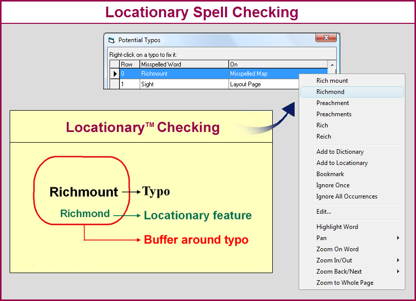
The term itself is made up from "location" and "dictionary". What are Locationaries? Locationaries are spatial dictionaries. They keep track of correctly spelled words along with the location in the world where those words are accurately spelled. MapSpeller spell checks both conventionally and spatially. Conventional dictionaries, which are lists of words that are deemed correctly spelled, don't offer the ability to take the geographic/coordinate location of words in maps into consideration when proofing them; Locationaries do. Locationaries are "maps" of correctly spelled words, maps of dictionary words.
Locationaries and Data Frame Objects Spatial spell-checking is the ability to proof a word while taking the geographic/coordinate location of such word into consideration. The primary purpose of Locationaries is to enable spatial spell checking of location-bound words within a data frame. Map annotations and geodatabase contain such words. Radius spell-checking is the process of proofing words by specifying that words will be considered correctly spelled if they are located within a certain distance (the radius) of a Locationary feature. Radius spell-checking can also be used to detect:
Locationaries and Layout Page Objects Locationaries can also be used to indirectly proof non-location-based text residing on the layout page. Locationary words used to check data frames can be temporarily exported into a conventional dictionary and then re-used to proof words from the layout page. This is particularly useful in proofing layout text that contains the names of localities being mapped, such as in layout titles. Locationary Format In technical ArcGIS terms, a Locationary can be thought of as a new type of feature class, a feature class of dictionary/Locationary features. Each Locationary feature consists of a record in the feature class attribute table that stores or tracks a correct spelling (the Locationary word) as well as a corresponding polygon (or multi-part polygon) that represents the minimum geographic area of validity of the Locationary word (or combination of words).Locationaries are however different from standard GIS feature classes by, for example, the meaning of a feature, the fact that features don't have to represent real-word objects; the fact that they are not built thematically (roads versus towns). Locationaries can be made language dependent or not by end users. At MapSpeller 4.0, Locationaries are currently implemented as theme-independent polygon shapefiles. They are theme-independent in the sense that, unlike conventional feature classes, they can contain all sorts of polygon features, including parcels, buffered roads, buffered name places, etc. The only common characteristics between those features is that they all have to:
Locationary Types and Availability They are two types of Locationaries: personal and shared. Those types of Locationaries are analogous to personal and enterprise dictionaries.
Adding or Removing Locationary Features MapSpeller provides a couple of interfaces for adding or removing features from personal Locationaries. Users can also take advantage of the fact that all Locationaries have the same format as polygonal feature classes and therefore can be edited using well-known ArcMap procedures. |
| Related Topics |
|
|
| MapSpeller™ for ArcGIS® Page last updated on October 07, 2017 Copyright © 2001-2013 Edgetech America, Inc. All Rights Reserved. |
|
|