|
Purpose of Locationaries
MapSpeller Locationaries are one of the
types of dictionaries supported by MapSpeller. They are primarily
used in
spatial spell-checking.
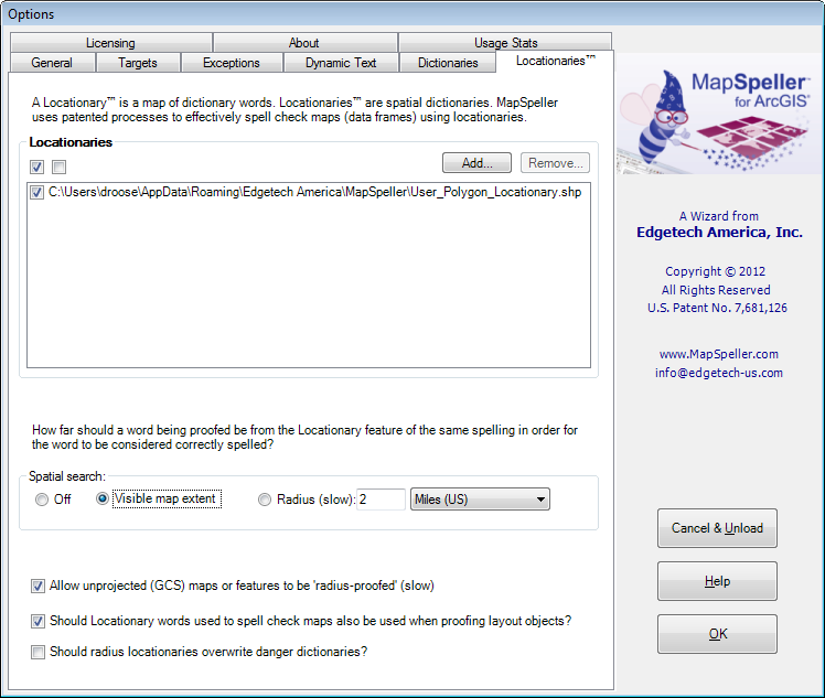
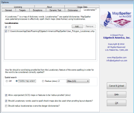
The Locationaries tab of the MapSpeller Options dialog lets users decide
which Locationaries should be used and how.
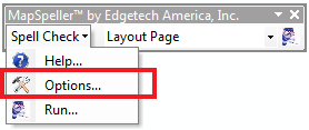
Dialog Access
The Locationaries tab is accessed from the MapSpeller toolbar by selecting
Options from its menu and then clicking on the Locationaries tab in the
Options dialog.
Adding or Removing Enterprise
Locationaries
Within the Locationaries tab, the Locationaries control group lets users
add or remove enterprise Locationaries using the Add or Remove buttons.
The only
enterprise Locationary format available at the time of this writing
are Locationary shapefiles.
The personal Locationary can't be removed from this list.
Activating or Deactivating Locationaries
Locationaries can be in the Locationaries list without and not be active,
being used when proofing maps and data. To activate or deactivate a
Locationary,
- Check or uncheck the box that precedes it in the list,
AND
- Specify the Spatial search criterion.
Spatial Search Criteria
If the spatial search is set to Off, no Locationary will be used when
proofing maps and data.
At MapSpeller 4.0, the spatial search criterion applies to all checked Locationaries.
The spatial criterion determines the spatial relationship Locationary
words should have with the word being proofed to be considered. The
options are currently:
- Within the current visible extent. With this option selected, the
MapSpeller spell-checker will consider all Locationary features within the currently visible
map extent as dictionary words. This is the default option.
- Within a radius around the word to spell check. When this option is
selected, the MapSpeller spell-checker considers only Locationary
features that are at least partially within a user-specified
distance of the word being spell checked. This
is the most precise method but also the slowest, as Locationary
features must be selected geographically for each word being
checked.
Fine-Tuning Locationary Usage
The three checkboxes at the bottom of the dialog fine-tuning how
Locationaries are used.
- The Allow unprojected (GCS) maps or features to be
'radius-proofed' (slow) checkbox lets users control if
MapSpeller should be allowed to use Locationaries to proof map data
or feature classes that are in a geographic coordinate system. If
the user is willing to wait for the extra processing time,
MapSpeller will project each object being proofed into an Azimuthal
Equidistant projection optimized for the center of the object. This
is needed as distances are not constant throughout geographic
coordinate systems and are used in radius-proofing.
- The
Should Locationary words used to spell check maps also be
used when proofing layout objects? checkbox will let MapSpeller
use the Locationary words it encountered while proofing data frames
as dictionary words when it proofs objects on the layout page.
Edgetech recommends keeping this box checked as it is very handy to
avoid false errors in layouts where geographic names from data
frames are used, for ex. in the title of the layout page.
- The Should radius Locationaries overwrite danger
dictionaries? checkbox is off by default meaning that if a word
has been flagged in a danger dictionary as potentially representing
an error, MapSpeller will display it in its Potential Error dialog.
This is the safest option as users can then decide what to do with
the word. However, it's possible that some points of interest, some
geographic features have particularly colorful and potentially not
politically correct names. If one is highly confident in the quality
of his/her Locationaries, checking the box will prevent false hits.
|