|
|
Version 4.0 |
Spatial Spell-Checking (U.S. Patent No. 7,681,126)
|
||
|
Spatial Spell-Checking (U.S. Patent No. 7,681,126) |
||
|
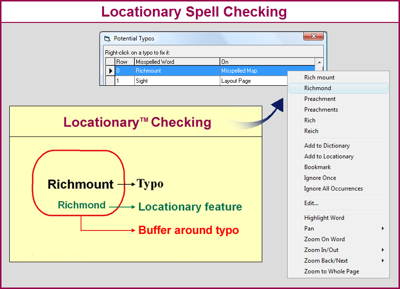
What is Spatial Spell-Checking? Spatial spell-checking is the ability to proof a word while taking its geographic/coordinate location into consideration. The primary purpose of Locationaries is to enable spatial spell checking of location-bound words within a data frame. Map annotations and geodatabase features are ArcGIS objects containing such location-bound words. Why Spell-Check Spatially? While conventional spell-checking and dictionaries are well suited for proofing language words, they are not well suited for proofing geographic names and other location-bound words. This is because the latter have spellings that are only valid locally, not worldwide as dictionary words. Location-bound words refer to real-world entities (such as names of places, streets) or any word that has a defined geographic extent of validity. Adding those words to conventional dictionaries would pollute such dictionaries in all geographic areas where those spellings are not accurate. How Does Spatial Spell-Checking Work? In MapSpeller 4.0, spatial spell-checking is implemented via spatial dictionaries called Locationaries™. Basically, if there exists a locationary word with the same spelling and within a user-defined spatial criterion of the word being proofed, that word is deemed correct spelled. Otherwise, it is considered a potential error and MapSpeller will then search for similar words in its geographic proximity and offer them as potential replacements. For more information on the spatial operators, read the Setting MapSpeller Locationaries page.
|
| Related Topics |
|
|
| MapSpeller™ for ArcGIS® Page last updated on October 07, 2017 Copyright © 2001-2013 Edgetech America, Inc. All Rights Reserved. |
|
|