GIS Map Gallery:
|
Natural hazards, such as tornadoes, are important to corporate and industrial site selection. Not only could those hazards destroy properties but they can significantly disturb the operations of company headquarters or plants. Express couriers may not be able to reach the facility, telecommunications may be greatly reduced, employees may try to recover and not be able to go to work...
| Source: | National Climatic Data Center |
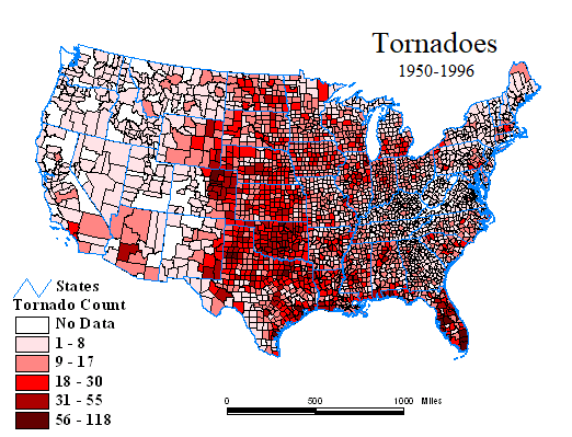
| Map Basis: | Based on recorded historic tornado landfall locations showing date and scale event |
| Date: | 1950 - 1996 |
| Data Scale: | Data aggregated to county level from actual tornado landfall locations - number of events per county |
| Even though tornadoes are
short-lived, the are nature's most violent atmospheric phenomenon, capable of destroying
buildings. The United States has the dubious distinction of having the most severe,
damaging tornadoes of any country in the world. The combination of moisture, cold
air and strong winds east of the Rocky Mountains provide the perfect ingredients for
tornado formation. The Fujita-Pearson Tornado Intensity Scale (F0-F5) is used to measure tornado wind speed. It is based on the storm's damage rating, path length, and mean path width. "Significant" damage occurs at the F2 classification where wind speeds are in the 73-112 mph range. "Devastating" (F4) and "Incredible" (F5) damage occur in the 200 and over 260 mph range. This map was compiled by counting the number of significant tornadoes (those with a Fujita-Pearson rating of F2 or greater) per county. The data is distributed in five classes using the natural break methodology. This method finds grouping and patterns inherent in the data through the identification of breakpoints between classes using a statistical formula (Jenk's optimization) that minimizes the sum of the variance within each of the classes. Natural Breaks finds grouping and patterns inherent in the data. |
|
1 North Carolina Division of Emergency Management
| Contact Us | Home | MapSpeller | Maps |
Copyright © 1997-2017. Edgetech America, Inc.
October 07, 2017