 |
GIS Map Gallery:
|
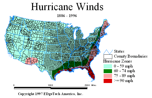
Natural hazards, such as hurricanes, are important to corporate and industrial site selection. Not only could those hazards destroy properties but they can significantly disturb the operations of company headquarters or plants. Express couriers may not be able to reach the facility, telecommunications may be greatly reduced, employees may try to recover and not be able to go to work...

| Source: | National Hurricane Center - Atlantic and Western Pacific Databases |
| Map Basis: | Based on recorded historic hurricane tracks showing hurricane category (based on wind speeds) |
| Date: | 1886 - 1996 |
| Data Scale: | Data aggregated to sub-county level from actual hurricane track center locations |
| Hurricanes (or Tropical
Cyclones) cause damage an destruction from high winds, river flooding that results from
intense precipitation, and storm surges (wind-driven oceanic waters). The property
damage from hurricanes can be staggering. The Saffir-Simpson Hurricane Scale is a 1-5 rating based on a hurricane's present intensity. This is used to give an estimate of the potential property damage and flooding expected along the coast from a hurricane landfall. Wind speed is the determining factor in the scale, as storm surge values are highly dependent on the slope of the continental shelf in the landfall region1. A category 1 hurricane on the Saffir-Simpson scale has wind speeds of 96-110 mph. It can cause damage to roofing material, bulking doors and windows, and considerable damage to mobile homes. Higher category hurricanes are even more destructive. This map shows the wind speeds of historical hurricanes. The higher risk counties along the Gulf and Easter seaboard are clearly shown. |
|
1National Centers for Environmental Prediction
| Contact Us | Home | MapSpeller | Maps |
Copyright © 1997-2017. Edgetech America, Inc.
October 07, 2017