GIS Map Gallery:
|
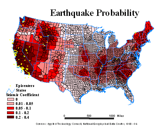
Natural hazards, such as earthquakes, are important to corporate and industrial site selection. Not only could those hazards destroy properties but they can significantly disturb the operations of company headquarters or plants. Express couriers may not be able to reach the facility, telecommunications may be greatly reduced, employees may try to recover and not be able to go to work...
| Sources: | Applied Technology Council National Geophysical Data Center |
| Map Basis: | Based on acceleration of gravity and epicenters of actual significant events showing magnitude of event (Richter scale) |
| Date: | 1900 - 1994 |
| Data Scale: | Data aggregated to county level |
Seismic risk maps for the United States are based on either relative hazard or probability. The probabilistic approach to seismic risk, while more complicated, is currently the preferable method1. This Earthquake Probability Map uses seismic coefficient as an indicator for earthquake probability. It displays the counties where maximum values of horizontal ground acceleration caused by seismic shaking that, with a 90% probability, are not likely to be exceeded in 50 years. The darkest red areas represent the greatest seismic hazard, interpreted as an area where the horizontal acceleration from seismic shaking of greater than four meters per second per second (40% of the acceleration of gravity) can be expected, with odds of only one in ten to be exceeded in a 50 year period. The seismic data is distributed in five classes using the natural break methodology. This method finds grouping and patterns inherent in the data through the identification of breakpoints between classes using a statistical formula (Jenk's optimization) that minimizes the sum of the variance within each of the classes. Natural Breaks finds grouping and patterns inherent in the data. For additional information, the Earthquake Probability Map was overlaid with the location of past significant earthquake epicenters from the National Geophysical Data Center. The original seismic coefficient data used to produce this map originated from the Applied Technology Council (ATC), a non-profit corporation set up by the Structural Engineers Association of California. |
|
1 Keller, Edward A., 1989, Environmental Geology, p.121
| Contact Us | Home | MapSpeller | Maps |
Copyright © 1997-2017. Edgetech America, Inc.
October 07, 2017