What is GIS?
The most advanced database system available today.
What is GIS?The most advanced database system available today. |
|
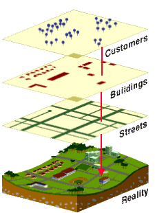
GIS stands for Geographic Information System. One may think of GIS as a map making software. It is, but it's much more than that. It is the most advanced database technology available as it ads spatial intelligence to the database of your choice. Such systems manage geographically-referenced information by integrating a database and a mapping software and by providing the tools to analyze spatial relationships between events or phenomena.
 GIS is an important technology because
"Everything Happens Somewhere". Geography (the location of things)
and time are often the only common characteristics between seemingly unrelated events.
GIS integrates information on these events by tracking their locations.
For example, in the USA, you can find the average household income in your
neighborhood and querying the US Census GIS database
by location. In a similar manner, you can locate known polluted sites close to
your neighborhood by querying the US EPA Superfund Sites database
geographically. You could also find out in which income-level neighborhoods Superfund sites
are predominantly located nationwide.
GIS is an important technology because
"Everything Happens Somewhere". Geography (the location of things)
and time are often the only common characteristics between seemingly unrelated events.
GIS integrates information on these events by tracking their locations.
For example, in the USA, you can find the average household income in your
neighborhood and querying the US Census GIS database
by location. In a similar manner, you can locate known polluted sites close to
your neighborhood by querying the US EPA Superfund Sites database
geographically. You could also find out in which income-level neighborhoods Superfund sites
are predominantly located nationwide.
GIS also provides the tools to analyze spatial relationships within data. For example, it can be used to determine the labor pool within a 35-minute drive of a business park. The computer will "drive" 35 minutes away from the business park on existing roads at specified speeds in all directions, establish the area covered and query another database to find out the labor pool.
GIS communicates information efficiently. If a picture is worth a thousand words, a map may be worth a thousand pictures! The amount of information that can be communicated within a single map is tremendous and yet easy to grasp. But avoid a distracted audience, spell check your maps first!
These characteristics are what makes GIS the most advanced database system available today. GIS is used by government, businesses and individuals worldwide.
| Contact Us | Home | MapSpeller | Maps |
Copyright © 1997-2017. Edgetech America, Inc.